 |
| That's all! |
2012.06.01 Going Home!
Time to go home. This trip has been great, but I'm so tired. This trip has been so very educational, but also very draining. It's been a lot of traveling and hard work, but not a lot of personal space or time. I saw more of the NW US with the Maymester field trip than I possibly could have on my own, and I found a few places along the way that I really want to return to one day. I should probably start planning this out now.
2012.05.31 Lawn Lake Flood and Rocky Mountain High
 Just pictures again. I'm suffering serious sleep deprivation at the moment and can't think. But I can pick up a camera and snap pictures. These are from a few days ago, but they tell a little bit of the story of the Lawn Lake Flooding event and what the area looks like now.
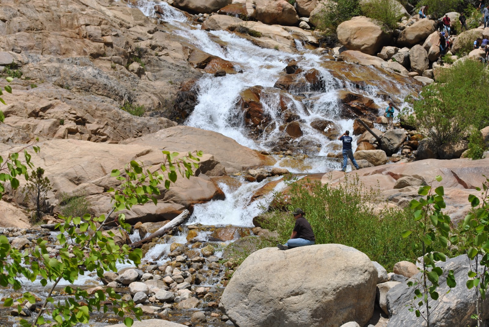
  |
| The large rocks were deposited when this stream had a much higher competency rate, during the flood. |
 |
| These large rocks would have been moved by much more water at much greater speeds. |
 |
| Had this flooding event occurred without witnesses, geologists would use clues such as these large misplaced rocks to tell the story of the land. |
 |
| Matt and Sal attempt to... I'm not really sure what they were doing. |
 |
| We might be smiling, but I think Buffy and I both had a little altitude sickness. |
2012.05.30 Devils Tower
 Devils Tower! This was great. We all wore silly aluminum foil
hats and scared the other tourists. If a picture is worth a thousand words,
here are a few thousand for you!
Devils Tower! This was great. We all wore silly aluminum foil
hats and scared the other tourists. If a picture is worth a thousand words,
here are a few thousand for you! |
| Obviously, the aluminum foil is to prevent aliens from reading our thoughts. |

 |
Wait, it gets better. Before getting to Devils Tower, we stopped in a little town called Bill, Wyoming. Population 11. And they sold t-shirts! We quadrupled the population for a few minutes. The picture below- that's the whole darn town!

2012.05.27—2012.05.29 Yellowstone, Big Decisions, and Rocky Mountain National Park

 The trip did in fact change. Though there was no snow on the
ground this morning, there was still a nasty band of ice and snow heading for
Glacier National Park, so we decided to head to Rocky Mountain National Park
instead. The weather was so nice
compared to Yellowstone. Dry, cool (well, cold), but no rain, no sleet, no
snow, no wet socks. There we checked out
moraines, tundra, talked about glacial features and how glaciers carved out the
mountains and lakes. Then we camped out,
and the next morning we were entertained with stories of bear attacks and more
bear attacks by the wonderful Ranger George Weaklim. I think the change of plan was great, and we stayed
for two days. Bonus—we finally had campfire astronomy with Dr. Cruzen, which
really helped ease my mind about some of the astronomy work that’s coming up in
the near future.
The trip did in fact change. Though there was no snow on the
ground this morning, there was still a nasty band of ice and snow heading for
Glacier National Park, so we decided to head to Rocky Mountain National Park
instead. The weather was so nice
compared to Yellowstone. Dry, cool (well, cold), but no rain, no sleet, no
snow, no wet socks. There we checked out
moraines, tundra, talked about glacial features and how glaciers carved out the
mountains and lakes. Then we camped out,
and the next morning we were entertained with stories of bear attacks and more
bear attacks by the wonderful Ranger George Weaklim. I think the change of plan was great, and we stayed
for two days. Bonus—we finally had campfire astronomy with Dr. Cruzen, which
really helped ease my mind about some of the astronomy work that’s coming up in
the near future. |
| This is education at its best! |
2012.05.26 Yellowstone, Earthquake Lake, Too Much Snow
 What a trying day. The tent was covered in six inches of
snow this morning when we crawled out. I cannot believe it did not collapse on
us in the middle of the night, some of my classmates were not so lucky though.
We then spent the morning visiting Huckleberry Ridge, the Lava Creek Tuft, and
the Montana Quaternary Faults. When the sun finally peeked out we stopped to
check the weather and learn about the destruction at Earthquake Lake in the
1950’s. Then we spend some time at Duck creek collecting sediment samples and
talking about the types of rocks.
What a trying day. The tent was covered in six inches of
snow this morning when we crawled out. I cannot believe it did not collapse on
us in the middle of the night, some of my classmates were not so lucky though.
We then spent the morning visiting Huckleberry Ridge, the Lava Creek Tuft, and
the Montana Quaternary Faults. When the sun finally peeked out we stopped to
check the weather and learn about the destruction at Earthquake Lake in the
1950’s. Then we spend some time at Duck creek collecting sediment samples and
talking about the types of rocks.
It may be important to note that the campsite we have been
in at Yellowstone DOES NOT HAVE SHOWERS. By the end of the day I’d been four
days without taking a shower, as had all of my classmates. Luckily, we were
able to find the Lodge, where you could shower for as long as you wanted for
less than five bucks. That shower has so far been the highlight of my trip.
Also, due to the terrible weather, we may be changing the
trip itinerary. I guess we’ll find out what we’ll be doing tomorrow. I’m so glad our tent was still up, so no set up in the dark. Of
course, we weren’t able to hit the sleeping bags until late anyway.
By the way, my camera froze to death. There will be limited pictures until I can replace or fix it.
2012.05.25 Yellowstone, Wildlife, and SNOW!!
Let's take a break from geology for a minute. I have several pictures of the wildlife in Yellowstone that might be more interesting to see. But, if you need a geology fix, scroll down to the bottom to see a fumarole!


I awoke to a snow covered ground! In a tent! The day was
mostly window geology again, which showed us fumaroles, Palette Springs, and a quick stop (IN THE
SNOW) to measure the dip and slip of exposed rocks using the Brunton
compasses. The nasty weather is not
conducive to learning, but we are trying.
2012.05.24 Unknown... Jackson Hole, Maybe?
I was sick, so I barely remember anything about
this day. In fact, I think I slept the entire time I was in the van.
Fortunately, I have pictures that say I must have been in Jackson Hole, WY. Seriously, if this picture were not right before the Yellowstone Pictures, I wouldn't have had an entry for this day.
Thankfully we got to set up camp in daylight, then we had an astronomy lesson since this was the first night the skies were clear.
Fortunately, I have pictures that say I must have been in Jackson Hole, WY. Seriously, if this picture were not right before the Yellowstone Pictures, I wouldn't have had an entry for this day.
 |
| These are antlers. I vaguely remember that Ute was very disturbed by this. |
Thankfully we got to set up camp in daylight, then we had an astronomy lesson since this was the first night the skies were clear.
2012.05.23 Bear Lake State Park

So, a little about Bear Lake—it’s a graben, it was formed
by upthrown faults. The lake is very long, because it was probably a river that
was naturally dammed when the horst (the mountains) were forced upward. Some
of the evidence to that are soft sediment deposition, trees that were in
areas that were covered with salt water,
and terraces along the sides that show the river flowed further than the
lake.
Guess when we set up camp.
Guess when we set up camp.
 |
| Actually, setting up camp late every night became fun after while. We look like we're having fun, right? |
2012.05.22 Utah, Bingham Canyon, and Salt Lake
Utah was far greener than I expected. The Wasatch Front gave me a view of new geomorphic features—triangular
facets, flat irons, and a long series of alluvial fans. There were nice to look at, but all of the
mountain ranges had started to run together .
The weather was really different, again. There was a thick haze in the
sky. Basically, the salts from Salt Lake
are in the air and are the perfect particulate matter for air to create haze.
Okay, really, I’m not 100% clear on this process, but I’m getting it.

 Later in the day we drove up a mountain to see the Bingham
Canyon—only the largest copper mine in the world! The view was incredible, the wind
was strong enough to knock down a small child, and the one lane mountain road
that twisted and had at least eight hairpin turns that led to the top of the
mountain… well that was just terrifying.
Horrifyingly scary. But once we made it to the top we learned how the
copper mine literally destroyed the town. Poor mining practices caused the
water to become poisoned and it remained that way today. Water is pumped in
from outside the area for the residents that remain.
Later in the day we drove up a mountain to see the Bingham
Canyon—only the largest copper mine in the world! The view was incredible, the wind
was strong enough to knock down a small child, and the one lane mountain road
that twisted and had at least eight hairpin turns that led to the top of the
mountain… well that was just terrifying.
Horrifyingly scary. But once we made it to the top we learned how the
copper mine literally destroyed the town. Poor mining practices caused the
water to become poisoned and it remained that way today. Water is pumped in
from outside the area for the residents that remain.
 We finished the day at Salt Lake. I’ve always imagined salt
lake to be like an inland ocean. It’s not. It smells terrible, not the pleasant
saltiness of the sea, but a rancid gagging smell that coats the hain and
clothing for days. Sewage is dumped in the lake because it is nearly useless for
any other living things (except sea monkeys, apparently, but even thay can only
live for a short time).
We finished the day at Salt Lake. I’ve always imagined salt
lake to be like an inland ocean. It’s not. It smells terrible, not the pleasant
saltiness of the sea, but a rancid gagging smell that coats the hain and
clothing for days. Sewage is dumped in the lake because it is nearly useless for
any other living things (except sea monkeys, apparently, but even thay can only
live for a short time).
Again, we set up camp in the dark. It’s become a theme. But
during the night I heard both cows, and waves. Do they raise cattle on the
beach here?
2012.05.21 The Book Cliffs and Arches National Park
 |
| Smile- this is awesome! |
 |
| Sal and Vince explain the Brunton compass. |
 |
| These are massive! But they look so fragile. |
 |
| Gift shop! T-shirts! |
The weather was exceptionally dry; our weather readings indicated that the humidity was less than 10%. Even though I sucked up four 32 oz. bottles of water my eyes felt dry and scratchy and I barely sweat at all.

Then we set up camp in the dark. Again.
2012.05.20 Cedar Bluff State Park, the Rocky Mountains, and One Spectacular Eclipse
Today is the day Dr. Cruzen has been waiting for—the annular
eclipse. We made a mad dash to get to a
location that would offer exceptional viewing of the eclipse, so we did a lot
of 45mph window geology.
The Rocky Mountains came into view just outside of Denver,
CO.


The eclipse was spectacular--about 90%. I'm so happy I was able to take a decent picture of the event. It was also near the end of the
day, so by the time we made it to the campground, it was dark.
2012.05.19 Kansas River and Thunderstorms
 Since we set up camp in the dark the night before, I was
surprised by my surroundings when the sun came up on day two. We were in the Ouachita’s and only a short walk from the Kansas River. One bank was very white,
sandy, and very fine (point bar). The other was rocky and covered in vegetation
(cut bank). The very width of the point
bar tells that the river floods, probably regularly.
Since we set up camp in the dark the night before, I was
surprised by my surroundings when the sun came up on day two. We were in the Ouachita’s and only a short walk from the Kansas River. One bank was very white,
sandy, and very fine (point bar). The other was rocky and covered in vegetation
(cut bank). The very width of the point
bar tells that the river floods, probably regularly.
This day added to my tasks. Everyone in the van was assigned
a different weather instrument and at every stop I had to check the barometric
pressure and record that, as well as measurements for temperature, wind,
humidity, and gusts. We took four readings before we got to Oklahoma. Then the
weather changed. We watched as the clouds grew heavy, formed a wall cloud, and
the sky opened. We survived our first Great Plains thunderstorm. The following pictures show the progression of the storm as it builds.
 |
| The sky started to grow darker. |
 |
| Mammatus clouds formed. I'd never seen these outside of a book. |

 |
| Rain in the distance--we got a few sprinkles on the windshield, but nothing to get worried over. |
The day ended in Cedar Bluff State Park in Kansas, where we
set up camp in the dark again.
2012.05.18 Alabama to Arkansas...I Think

 It’s only the first day of this trip and I am already blown
away by how much I just don’t know.
Within the first few hours I was searching for clues to the geology of
the land—discussing the rolling hills, how hoodoos are formed, areas of tornado
damage, and how different strata (layers) formed. We stopped at a road cut outside Birmingham,
AL to determine what type of rock was there, and why it was important to break
the rock to determine the real color, not just the surface color that might be
stained by minerals as they are weathered. Then, west of Jasper, we learned
about faulting and coal formation.
It’s only the first day of this trip and I am already blown
away by how much I just don’t know.
Within the first few hours I was searching for clues to the geology of
the land—discussing the rolling hills, how hoodoos are formed, areas of tornado
damage, and how different strata (layers) formed. We stopped at a road cut outside Birmingham,
AL to determine what type of rock was there, and why it was important to break
the rock to determine the real color, not just the surface color that might be
stained by minerals as they are weathered. Then, west of Jasper, we learned
about faulting and coal formation. 
It was a busy day that ended in Arkansas with a radio
broadcast chat between the four vans about the sunset and how the pink to
purple to orange light cast on the horizon is caused by scattered light—longer
wave lengths equal more red light
because of the angle he light strikes the earth. We then set up camp in the
dark. It’s a good thing we practiced at home before the trip.
Subscribe to:
Posts (Atom)